GLONASS is the Global Navigation Satellite System developed by Russia. In 1982, four years later since the first launch of the first GPS satellite in 1978, the satellites Cosmos-1413,1414 and 1415, were launched as the Russian alternative to GPS. Then, it started the GLONASS constellation which has been fully operating since 1995.
GLONASS’ constellation is currently formed by 29 satellites (24 operational + 2 spares + 2 in flight tests +1 under check by the Satellite Prime Contractor) situated in three different planes at 25.510km (8 operational satellites by plane), approximately one thousand kilometers closer than GPS (26.560km), both in LEO. The continuous change in technology and the lifetime of the satellites has caused the apparition of already 3 different GLONASS generations. The first one, GLONASS with a lifetime of 3 years, now out of service. A second generation, GLONASS-M, first launched in 2003 with a lifetime of 7 years. And last, GLONASS K-1, the third generation, first launched in 2011 with 10 years of lifetime.
The company, Information Satellite Systems Reshetnev, which is developing this positioning system, has already started to move to GLONASS K-2. However, they have faced some issues related to the technology complexity that will delay the development of K-2 satellites at least a year or two.
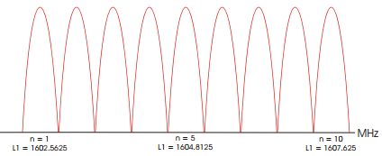
Another important feature from GLONASS is its L1 and L2 frequencies, between 1598.0625 and 1609.3125 MHz for L1 and between 1242.9375 and 1251.6875MHz for L2, which are a bit lower than L1 and L2 from GPS. L1 and L2 in GLONASS are used by devices to receive the position and these information is coded by P-codes and C/A-codes, remember when we talked about GPS, that P-Codes are used for military and C/A-codes for civilian applications. In Figure.1 we can observe how GLONASS use this L1 frequency (the same case from L2). Actually, the reason to see these 12 channels of 0.5625 MHz bandwidth each (in Figure.1 are missed 3 last channels to arrive to 1609.3125MHz + 2 more bands use for tests) is because GLONASS uses FDMA (Frequency Division Multiple Access) instead of CDMA (Code Division Multiple Access) as GPS or GALILEO do. The aim to do so is to identify their satellites, in other words, each satellite will use only one channel and in this way they can be identified. The fact that only 12 divisions have been made is because the satellites are antipodal, which means that all the satellites will find another one located at 180º from itselves in the same plane, thus, it will be imposible to see from a point on Earth more than 12 GLONASS satellites.

GLONASS L1 FDMA
In order to conclude, GLONASS uses UTC(SU) atomic time scale. A maximum difference between clock satellites of 1ms (milisecond) and typically better than 1us (microsecond) is achieved. As is a Russian system this UTC(SU) is added 3 hours (Moscow local time) from the UTC+0, so UTC(SU)+3.
All these technologies provide to the user an horizontal positioning accuracy within 5–10 meters, a vertical positioning within 15 meters, a velocity vector measuring within 0.1m/s, and timing within 200 ns. However, all this accuracy data has been measured before the new GLONASS satellite generations had been installed so, surely, the parameters nowadays, are much better.
GLONASS as a GNSS has lots of other parameters and features, so, in case you are interested in extend your knwoledge about GLONASS you can do it from the links below.
Sources
Navipedia GLONASS articles (one and two)

